
How Cyclone Fani got its name and what it means
The name for this cyclone was suggested by Bangladesh.The World Meteorological Organisation (WMO) has devised a mechanism where countries submit a list of names from time to time. Names of cyclones are chosen from this pool.
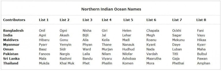
For tropical cyclones developing in the North Indian Ocean, countries like India, Sri Lanka, Bangladesh, Maldives, Myanmar, Oman, Pakistan and Thailand send their names to the regional tropical cyclone committee.
At present, all eight countries have submitted eight names each for naming future cyclones. The name Fani was chosen from this list containing 64 names
The word Fani (pronounced as Foni) means snake.
In 2018 Cyclone Titli hit Andhra Pradesh and parts of Odisha. This cyclone was named by Pakistan.
In 2017, Cyclone Ockhi caused severe damage in Kerala and parts of Tamil Nadu. Its name was given by Bangladesh.
The names given by India are: Agni, Akash, Bijli, Jal, Lehar, Megh, Sagar and Vayu.
Here is the list of names given by each countries:
How countries select names
While selecting names for cyclones, countries have to take care that the word is easily understood by people in the region, hence the names are generally familiar words.
"The main purpose of naming a tropical cyclone is basically for people to easily understand and remember the tropical cyclone in a region, thus to facilitate tropical cyclone disaster risk awareness, preparedness, management and reduction," WMO says in its explanation of how cyclones are named.
Another important reason why cyclones are named is to help authorities quickly identify storms and keep a track of them because it is easier to remember cyclones by their names than remembering them using technical information like longitude and latitude
Cyclone Fani, which has been classified as an extremely severe cyclone (ESC), is the 10th such cyclone to hit India in May in past 52 years.
Data from the India Meteorological Department (IMD) show that the last time an extremely severe cyclone hit India in May was in 2004.
The other years when such cyclones were witnessed in May are: 1968, 1976, 1979, 1982, 1997, 1999 and 2001.
Generally, extremely severe cyclones hit India's east coast in the post-monsoon season (October-December)
IMD data on cyclones that hit India between 1965 and 2017 show that the country has weathered 39 extremely severe cyclones in these 52 years.
Of these, nearly 60 per cent (23) were between October and December.
The India Meteorological Department (IMD) classifies cyclones on the basis of the maximum sustained surface wind speed (MSW) they generate
The cyclones are classified as severe (MSW of 48-63 knots), very severe (MSW of 64-89 knots), extremely severe (MSW of 90-119 knots) and super cyclonic storm (MSW of 120 knots or more). One knot is equal to 1.8 kmph
WHAT MAKES CYCLONE FANI SPECIAL
Timing and strength are two factors that make Cyclone Fani, pronounced as Foni, different from most other tropical cyclones in this time of the year.
Cyclone Fani started developing around April 25 and has made a landfall this morning in Odisha on the east coast.
Traversing for nearly 10 days over the sea allowed Fani to gather such strength that it is now classified as an extremely severe cyclone.
Generally, tropical cyclones over the Bay of Bengal have a lifespan of four-seven days. But Cyclone Fani is different.
It has been observed that cyclones/hurricanes/tornados that spend a long time travelling over the sea are generally more powerful than the ones that hit the landmass within a few days.
The reason is that the longer duration at sea allows storms to gather more water and momentum and thus generate stronger winds
Another aspect that makes Cyclone Fani special is its trajectory. Fani started developing around the Equator and moved upwards (see image below). It thus has had a much longer journey from its starting point to the point where it made a landfall, than other cyclones that generate in the Bay of Bengal

The IMD had first predicted that Cyclone Fani would make a landfall in Tamil Nadu but the forecast was updated as the cyclone altered its course. Had Cyclone Fani made its landfall in Tamil Nadu, it was possible that its strength would have been lower than its present strength because a landfall in Tamil Nadu would have meant that Fani would have covered a shorter distance over the sea.
Most cyclones that generate exclusively in the Bay of Bengal become relatively weaker by the time they reach the Indian landmass. However, the case with Cyclone Fani is different since it developed almost close to the Equator.
The World Meteorological Organisation (WMO), a United Nations body that monitors weather conditions, had said the extremely severe Cyclone Fani will make a landfall in Odisha with wind speeds of more than 170 km/h.
However, even after making the landfall, the cyclone will move north-northeastwards and strike West Bengal as a severe cyclone and is expected to hit Bangladesh on May 4 as a cyclonic storm.
This means that besides having covered a long journey over the sea (during which Cyclone Fani collected massive amount of moisture), the cyclone will also travel considerable distance over the land
The WMO has also warned that low-lying districts in Odisha are very likely to be flooded because a storm surge (rising of level due to storm) of about 1.5 metre height above astronomical tide is expected when Cyclone Fani hits Odisha.
The timing of Cyclone Fani is important because the cyclone started developing in April, a month that has historically seen very few cyclones that were categorised as extremely severe.
Between 1965 and 2017, India was hit by 145 cyclonic storms that were classified as severe, very severe, extremely severe and super cyclonic storm. Of these, only seven (5 per cent) were in April and 27 (18 per cent) in May.
Most of these cyclones (90 i.e. 62 per cent) were generated between October and December.
The Indian subcontinent experiences cyclones from two basins: the Bay of Bengal basin and the Arabian Sea basin. Of the two, more cyclones are generated in the Bay of Bengal and cyclones here have also been more severe than the one generated over the Arabian Sea.
One of the reasons why tropical cyclones are more prone to the Bay of Bengal is that its surface temperature is more than that of the Arabian Sea. Tropical cyclones generally need a temperature of around 28 degrees Celsius. The Bay of Bengal is more conducive to this than the Arabian Sea
The Indian subcontinent is considered to be one of the worst-affected regions by tropical cyclones. The region has witnessed some of the deadliest cyclones in world history.
According to the Nation Cyclone Risk Mitigation Project (NCRMP), the Indian subcontinent is exposed to "nearly 10 per cent" of the world's tropical cyclones. NCRMP's data analysis shows that between 1980 and 2000, on an average annually 370 million (37,00,000) people were exposed to cyclones in India.
A 2014 report of the World Meteorological Organisation, a United Nations organisation on weather monitoring, states that cyclonic storms have been the main cause of deaths due to natural disasters in Asia between 1970 and 2012. A majority of these cyclone-related deaths have occurred in India and Bangladesh.

The top three deadliest disasters in this period were all tropical cyclones. Two of them hit Bangladesh (in 1970 and 1991) and one hit Myanmar (Cyclone Nargis in 2008). The total deaths caused by just these three cyclones was 5,77,232.
HOW CYCLONES CAUSE DAMAGE
Cyclones are powerful storms that generate strong windspeeds and have the potential to trigger sudden and heavy rain in the affected areas.


There are basically 3 aspects related to cyclones that have the potential to cause
- destruction-flooding due to rising sea
- destruction caused by strong winds and
- damage due to heavy rains.
When a cyclone is formed over the sea, it generates strong winds along it. These winds have the potential to generate storm surges. A storm surge is an abnormal rise in the sea level due to a storm (cyclone, hurricane etc).
A storm surge becomes dangerous because it has the potential to flood low-lying areas along the coast. It can drown humans and animals, destroy infrastructure and damage environment by eroding beaches, flooding vegetation, among others.
The second dame-causing aspect of cyclones is the strong winds that are generated by the storm. These strong winds that accompany cyclones can uproot trees, electricity poles, shatter houses etc. This is a common phenomenon in the United States of America which regularly weathers strong hurricanes.
The third aspect with cyclones is their ability to cause sudden, heavy and prolonged rain in the affected areas. This causes floods in rivers, pollutes drinking water and if combined with storm surge, it becomes a double whammy.
Unfortunately, all the three factors occur at the same time when a cyclone makes a landfall. The IMD states that of three factors, it is storm surge that is most catastrophic and causes widespread destruction. "Past history indicates that loss of life is significant when surge magnitude is three metres or more and catastrophic when five metres and above," it says.
A possible reason for this could be that not much can actually be done against rising sea waves, especially if they are more than 3 metres in height. Storm surge becomes more dangerous if their timing coincides with the timing of high tides.
Cyclones hit Indian coasts in two seasons - May-June and October-November.
The month of November is considered the primary peak for cyclones while May is the time for secondary peak.
The NCRMP analysis of cyclones during 1891-2000 shows that while 308 cyclones (103 being severe) affected the east coast, only 48 tropical cyclones (24 being sever) crossed the west coast.
Of all the cyclones developing in the Bay of Bengal, over 58 per cent made landfall on Indian coasts in October and November. The corresponding number for cyclones originating in the Arabian Sea is 25 per cent. West is relatively peaceful.

No comments:
Post a Comment