Hurricane Irma brought ripping winds, tornadoes and storm-surge flooding to much of Florida's lower half on Sunday Sep 10,2017, as its slow-moving core battered the state's west coast from Key West to Tampa.
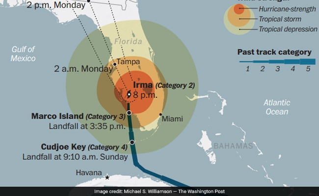
The massive storm - which had menaced Florida for days, and triggered evacuation orders covering 5.6 million people - made two official landfalls on Sunday Sep 10,2017
The first, at about 9:10 a.m., was over the Florida Keys, an isolated string of islands that had rarely felt more alone than on Sunday. Irma hit them as a Category 4 hurricane, with sustained winds near 130 miles per hour.
Little was heard from the islands for hours afterward because residents here had no way to connect with the outside world. Though hit with lengthy periods of hurricane conditions that led to significant flooding in well-known tourist areas, Key West was largely spared the onslaught that many feared. But the island was left with no power, water or cellphone service.
After the Keys, Irma crossed over warm waters and hit the U.S. mainland at last, about six hours later, near the beach town of Marco Island. By 5 p.m., the storm was hitting Fort Myers, moving north toward low-lying, vulnerable Tampa as a still-potent Category 2 storm.
But it was misleading to speak of this storm as "hitting" one city.
On Sunday, Irma was all of Florida's storm. Irma was everywhere.
In the east, the hurricane's spiraling rainbands were so wide that they caused tornadoes and flooding in Miami, on Florida's opposite coast. In the west, winds were so powerful that they bent the Gulf of Mexico itself to Irma's shape. In Naples, and in Tampa Bay, water actually disappeared from Gulf beaches, because Irma's counterclockwise winds were pulling it out to sea.
But not for long.
"MOVE AWAY FROM THE WATER," the National Hurricane Center warned, as curious onlookers climbed out onto the mysteriously dry seabed, moving so fast that it left manatees forlornly stranded. Later, after Irma's eye had passed, the same forces drove the water back in powerful surges.
By the end of the day Sunday, Florida officials said there were 568 shelters open across the state, holding 150,000 people.
More than 2.7 million people were without power as of 5:40 p.m., according to the state's estimate.

Irma's arrival as a Category 4 hurricane - the second-most powerful category, with sustained winds of at least 130 miles per hour - made history. Hurricane Harvey also hit Texas as a Category 4 storm, which marked the first time on record that two storms that powerful had made landfall in the U.S. in a single year. Scientists say that climate change is now making such intense hurricanes more likely, since hurricanes draw strength from warmer ocean waters.
And Irma seems likely to make more history before she is finished.
As the storm headed for Georgia, the city of Atlanta - hundreds of miles from any coast, and more than 600 miles north of the place where Irma first hit the mainland - was placed under its first-ever tropical-storm warning. The storm is forecast to arrive there on Monday, with wind gusts predicted at up to 63 miles per hour.
"Wind speeds that high literally can lift furniture off the ground and turn it into projectiles," Atlanta Mayor Kasim Reed (D) said. "We're already experiencing wind damage downtown."
Late Sunday, President Trump signed a disaster declaration that should speed federal funding to damaged areas in Florida. On the same day, a White House official - social media director Dan Scavino, Jr. - shared a photo of a flooded runway on Twitter. "Here is Miami International Airport," he wrote.
It was not. Officials at Miami International tweeted back to say that Scavino was wrong. It was unclear what airport was depicted in the video, which has circulated online for at least a few weeks.
The massive storm - which had menaced Florida for days, and triggered evacuation orders covering 5.6 million people - made two official landfalls on Sunday Sep 10,2017
The first, at about 9:10 a.m., was over the Florida Keys, an isolated string of islands that had rarely felt more alone than on Sunday. Irma hit them as a Category 4 hurricane, with sustained winds near 130 miles per hour.
After the Keys, Irma crossed over warm waters and hit the U.S. mainland at last, about six hours later, near the beach town of Marco Island. By 5 p.m., the storm was hitting Fort Myers, moving north toward low-lying, vulnerable Tampa as a still-potent Category 2 storm.
But it was misleading to speak of this storm as "hitting" one city.
On Sunday, Irma was all of Florida's storm. Irma was everywhere.
In the east, the hurricane's spiraling rainbands were so wide that they caused tornadoes and flooding in Miami, on Florida's opposite coast. In the west, winds were so powerful that they bent the Gulf of Mexico itself to Irma's shape. In Naples, and in Tampa Bay, water actually disappeared from Gulf beaches, because Irma's counterclockwise winds were pulling it out to sea.
But not for long.
"MOVE AWAY FROM THE WATER," the National Hurricane Center warned, as curious onlookers climbed out onto the mysteriously dry seabed, moving so fast that it left manatees forlornly stranded. Later, after Irma's eye had passed, the same forces drove the water back in powerful surges.
By the end of the day Sunday, Florida officials said there were 568 shelters open across the state, holding 150,000 people.
More than 2.7 million people were without power as of 5:40 p.m., according to the state's estimate.

Irma's arrival as a Category 4 hurricane - the second-most powerful category, with sustained winds of at least 130 miles per hour - made history. Hurricane Harvey also hit Texas as a Category 4 storm, which marked the first time on record that two storms that powerful had made landfall in the U.S. in a single year. Scientists say that climate change is now making such intense hurricanes more likely, since hurricanes draw strength from warmer ocean waters.
And Irma seems likely to make more history before she is finished.
As the storm headed for Georgia, the city of Atlanta - hundreds of miles from any coast, and more than 600 miles north of the place where Irma first hit the mainland - was placed under its first-ever tropical-storm warning. The storm is forecast to arrive there on Monday, with wind gusts predicted at up to 63 miles per hour.
"Wind speeds that high literally can lift furniture off the ground and turn it into projectiles," Atlanta Mayor Kasim Reed (D) said. "We're already experiencing wind damage downtown."
Late Sunday, President Trump signed a disaster declaration that should speed federal funding to damaged areas in Florida. On the same day, a White House official - social media director Dan Scavino, Jr. - shared a photo of a flooded runway on Twitter. "Here is Miami International Airport," he wrote.
It was not. Officials at Miami International tweeted back to say that Scavino was wrong. It was unclear what airport was depicted in the video, which has circulated online for at least a few weeks.
No comments:
Post a Comment